LIDAR IN ARBORICULTURE
Professionals in arboriculture – from forest managers to tree surgeons to ecologists – are starting to take advantage of a developing, laser-based technology.
LiDAR (Light Detection and Ranging) is a method of measuring distance. In the context of arboriculture, you might see the technology referred to as TLS (Terrestrial Laser Scanning).
It works by targeting a surface with a laser and measuring the time it takes for the reflected light to come back and hit the sensor. It can make digital, 3D maps of everything from the ocean floor to the surface of a single tree.
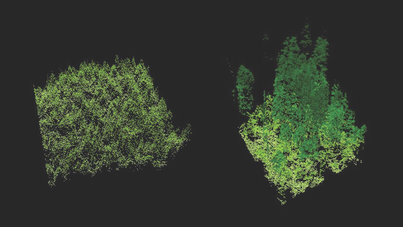
LiDAR's main advantage is the density of its samples, which make up "point clouds" - fields of data-points that can be used to map a three-dimensional space.
From macro…
National Trust planting scheme
The National Trust is using LiDAR technology to map the Wallington Estate in Northumbria – a 5,431 hectare (13,420 acre) site – to help decide where to plant 75,000 British native trees.
National Trust Archaeological Consultant Mark Newman said: “We can now plant with confidence, selecting areas for planting that avoid damaging any significant archaeological remains. But, and this is one of the things we are really excited about, we can now actually recreate areas of lost historic planting which we didn’t previously know about. It makes sense to mirror history. These areas should deliver even more habitat benefit than was originally intended and once again contribute to the picturesque qualities of the landscape while also restoring lost features of the historic environment.
Carbon analysis at Kew
Trees trap carbon dioxide in their wood, roots, and leaves. Finding out how much carbon is trapped in an area is useful for climate scientists, who usually estimate the volume of wood in a given area and make their calculations from that. But the Spatial Analysis team at Kew are using laser scans and models to gather more accurate measurements of the carbon stored in the above-ground wood of their trees (roots are still somewhat of an estimation game).
…to micro
LiDAR is now available to anyone with a new iPhone (12/13 Pro) or iPad (Pro, models since 2020).
For most users, the biggest benefit will be in improved camera quality and Augmented Reality apps. But for some professionals – including many arborists – the LiDAR tech is proving useful at work.
Paul Hanson, bts Senior Contract Manager in Scotland, has decades of experience working with – and consulting on – heritage and ancient trees, each of which displays the story of centuries. Being able to accurately map the landscape of a single tree is exciting, he explains.
“[The fact that] new iPhones come with LiDAR is absolutely terrific. You walk around a tree, taking a picture of it; it becomes a 3D image, which you can then save as a video and send it to a client.
“If you’ve got dramatic things happening – whether it’s fungal bodies in their prime, or cracks that are opening and closing in a gentle breeze – being able to show them on video is very helpful.”
Arb apps
Apps like Arboreal Tree Height have integrated LiDAR to improve their tree measuring tools. ForestScanner also makes direct use of the tech, allowing users to map areas and display data for individual trees.
Ash Dieback analysis
Mathias Disney (author of the Adventures with a laser scanner blog) and colleagues are using LiDAR in ingenious ways to measure the impact of ash dieback. Using a pump-up tower, the ecologists are able to map the canopy and understory of a plot, allowing them to examine the knock-on effects of Chalara to a tree’s surroundings.
Read more
LiDAR is a fast-moving topic, full of new developments. If it interests you, here’s a bit of further reading:
Applications of LiDAR in Forestry – Towards Data Science
Airborne laser scanning reveals large tree trunks on forest floor - ScienceDirect
And a couple of sites to peruse:
LiDAR News - news about LiDAR and related technologies
Sketchfab - a platform for 3D models. Lots of LiDAR users upload their scans to the site.
---
Featured image: Oregon State University via Wikimedia